Where Was Our Warming? It Was AWOL in the Arctic
|
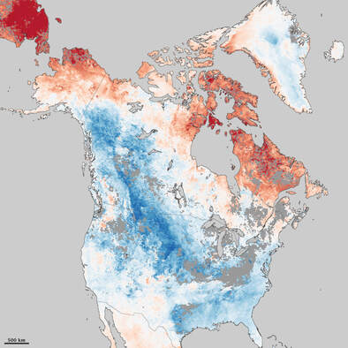
Snow coverage in the Arctic continues to shrink, as you can see from the accompanying map, But not here, not last winter. Here, in Nebraska, in February, it was as cold as a _______ _____. Fill in your own expletive.
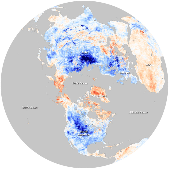
Our record cold and heavy snow in February does not mean that the whole Earth is cooling. It does mean that the upper air currents are twisting and turning in weird ways. Remember February 16? It was what? Minus 23? Record cold, of course. Was it a day when perhaps you wanted to ask Dr. What’s HOT in Global Warming? “Where is our global warming when we really need it?” Well, here I am, with a quick lesson in the geophysical facts, a.k.a. “The Climate Plays Tricks on Us”. The carbon dioxide level is still with us, at about 417 parts per million in 2021. It’s still holding more heat than it has in the last couple of million years. So what is going on? Climate involves changes over time. Weather is today’s wind in our faces. Weather is the story; climate is the plot. The coldest day I can recall in Omaha before February 16, 2021 was in December of 1983. It was a memorable day mainly for a low of about minus 22 F. That was temperature, not wind chill. I was walking along Dodge Street from Dundee, at about 52rd Street, westward during my second Omaha winter, to UNO, where I was beginning a 37-year career as an assistant professor of journalism when a man I had never previously met stopped his car in the midst of the busy street, leaned over, shoved the front door open, and commanded “GET IN!” “YES SIR,” I replied, escaping the coldest day of my life, until then. The Same Lows in Fairbanks and Austin One day apart on February 16-17, 2021, the forecast temperature bottomed at plus 7 F. in Fairbanks, Alaska (the average there is minus 13 F.). In Austin, the forecast low one day later was plus 7 (the average there in February is 45 F.). The fact that a coincidental low of 7 degrees F. was reached two days apart in Fairbanks and Austin is an atmospheric prank played on us by the Arctic Oscillation (map #2), in which the jet stream (which steers storms and upper-air wind patterns at a height of jet aircraft) flows north to Alaska, then back southward and eastward, plunging to the Gulf of Mexico, then north and slightly east up the U.S. East Coast, sucking relatively warm air, loaded with moisture, out of the Gulf Stream. That air circulates counter-clockwise around the storm, colliding with cold air over the land, causing the storm to intensify, wringing out prodigious amounts of snow over the United States’ northeast and Middle Atlantic states. The western side of the storm whips cold air into Texas and nearby states (also into the southern United States), often causing deadly ice storms. This is also a recipe for low temperatures such as 7 F. above zero in places such as Austin, Texas—roughly equal to much of Alaska at the same time, which is above average there. Arctic Ice Cover is Still Shrinking This pattern (and others, such as the “ice-albedo feedback”), considered as a whole, may affect the entire Northern Hemisphere. Again, thanks to NASA’s Earth Observatory, witness: “Throughout 2020, the Arctic Ocean and surrounding seas endured several notable weather and climate events. In spring, a persistent heat wave over Siberia provoked the rapid melting of sea ice in the East Siberian and Laptev Seas. By the end of summer, Arctic Ocean ice cover melted back to the second-lowest minimum on record. In autumn, the annual freeze-up of sea ice got off to a late and sluggish start. “Forty years of satellite data show that 2020 was just the latest in a decades-long decline of Arctic sea ice. In a review of scientific literature, polar scientists Julienne Stroeve and Dirk Notz outlined some of these changes: In addition to shrinking ice cover, melting seasons are getting longer and sea ice is losing its longevity. “The longer melting seasons are the result of increasingly earlier starts to spring melting and ever-later starts to freeze-up in autumn… Averaged across the entire Arctic Ocean, freeze-up is happening about a week later per decade. That equates to nearly one month later since the start of the satellite record in 1979. “The change is part of a cycle called the ‘ice-albedo feedback’. Open ocean water absorbs 90 percent of the Sun’s energy that falls on it; bright sea ice reflects 80 percent of it. With greater areas of the Arctic Ocean exposed to solar energy early in the season, more heat can be absorbed—a pattern that reinforces melting.” And, as a result, “The Arctic sea ice pack is becoming more fragile. In summer 2020, ships easily navigated the Northern Sea Route in ice-free waters, and even made it to the North Pole without much resistance.” |
ABOUT THE AUTHOR:
Bruce E. Johansen, Frederick W. Kayser Professor at the University of Nebraska–Omaha, is author of Climate Change: An Encyclopedia of Science, Society, and Solutions (2017).
|


